
Drone Land Surveying for Stockpile Measurements on Active Material Yards
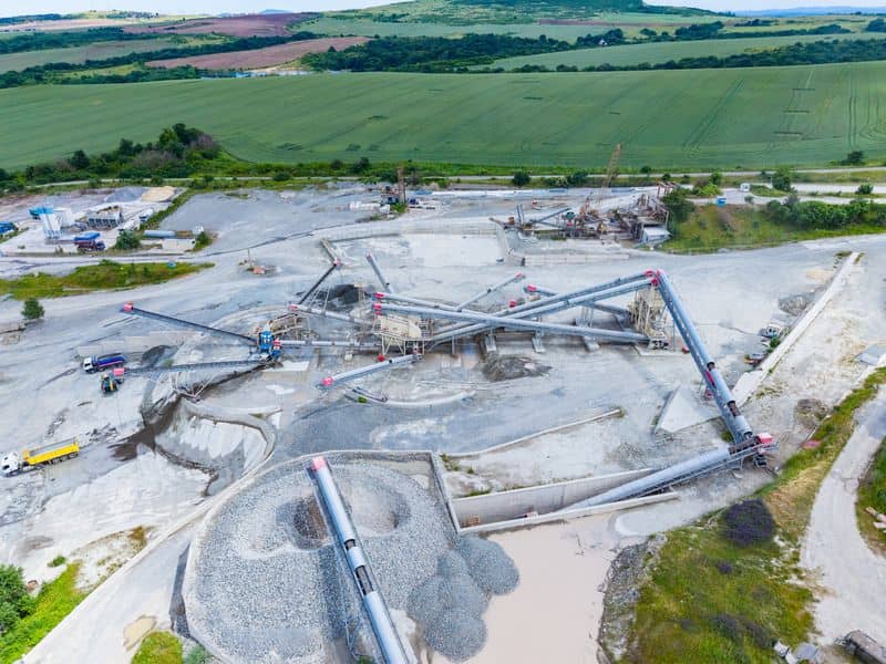
A pile of crushed stone can look the same from the scale house for weeks. Meanwhile, trucks haul thousands of tons in and out, and the numbers on paper slowly drift away from what’s really in the yard. Drone land surveying closes that gap by measuring every pile from above in one short flight.
For yard managers, contractors, and anyone who reports inventory, the payoff is simple. You get volumes based on measured surfaces instead of eyeball guesses. This guide covers how the process works, how to plan flights around a busy yard, and what to ask for so the final report is something your team can use.
How Drone Land Surveying Measures Stockpile Volumes
Drone land surveying measures stockpiles by capturing hundreds of overlapping images or laser scans and building a 3D surface of each pile. Software compares that surface to a base surface underneath, and the space between the two is the volume. Results are usually reported in cubic yards and can be converted to tons.
The base surface matters more than most people expect. On a flat concrete pad, it’s easy to define. On a dirt yard that’s been scraped and filled for years, the surveyor may need an earlier ground survey or a careful estimate from the ground around the pile’s edge. Ask how the base will be set before the first flight, since it can shift the numbers more than the drone itself.
There are two main capture methods. Photogrammetry uses camera images and works well for most aggregate, sand, and soil piles. LiDAR uses laser pulses and handles dark material and steep faces better, though it usually costs more.
Planning Drone Flights Around Active Yard Operations
The best stockpile flights happen when equipment is parked away from the piles and the light is steady. Early mornings, lunch breaks, or weekend slots often work well. A pile that’s being loaded during the flight will show a half-moved face that doesn’t match any count.
Safety comes first on an active site. The pilot should hold an FAA Part 107 certificate, and sites near airports may need extra airspace approval. Wind, low sun, and haul road dust can all hurt image quality, so leave some room in the schedule for a weather delay.
A short prep call saves a return trip. Most surveyors will ask for the same basic details. Have these ready before the flight date:
- Which piles need separate volumes and what material each one holds
- When loading and hauling usually pause
- Where power lines, conveyors, or tall structures sit
- Who on site can hold equipment if needed
Establishing Reliable Ground Control for Stockpile Surveys
Ground control points are marked targets that the surveyor measures with high-precision GNSS equipment. . The drone data gets tied to these points so the 3D model sits at the right position and elevation. Without good control, a model can tilt or float slightly, and that small error spreads across every square foot of a large pile.
On a working yard, control points should sit outside truck and loader paths. Marks on a concrete slab, nails in a curb, or monuments set near fence lines tend to last. Temporary targets are fine for a one-time count, but they’ll get run over if left in a haul lane.
Many drones now record very precise positions for each photo using RTK or PPK systems. That can cut down how many control points are needed. A few independent check points still let the surveyor prove the model’s accuracy instead of assuming it.
Turning Survey Data Into Usable Volume Reports
A good volume report lists each pile by name or material and shows its measured volume. It should also include the survey date, the accuracy checks, a map of the pile outlines, and a note on how the base surface was set. If your team needs tons, the report should state which density factor was used.
Density is where many inventory numbers go sideways. The drone measures space. It can’t weigh anything, so your density values should come from your own scale tickets or lab tests instead of a generic table.
Ask for files in formats your team already uses. Most managers want a PDF summary, a spreadsheet of volumes, and a marked-up aerial image. Estimators may also want the surface files for their own software.
Using Repeat Surveys to Track Material Inventory Changes
Repeat surveys show how much material came in or went out between two dates. Many yards fly monthly or quarterly to match their reporting cycle. Year-end counts for audits are another common reason, so check timing with your accountant.
Consistency is what makes repeat surveys worth the cost. Use the same control points, base surfaces, and pile boundaries each time. If a pile gets moved or split, the report should note it so the month-to-month numbers still line up.
Over time, the data helps with more than counting. You can compare surveyed volumes against sales records to spot loss or density problems. You’ll also see which piles are creeping toward roads or drainage paths before they cause trouble.
Frequently Asked Questions
How accurate is drone stockpile measurement?
Accuracy depends on ground control, the capture method, and how well the base surface is defined. With good control and a clear base, results often land within a few percent of the true volume. Large piles usually measure more reliably than small, irregular ones. Ask your surveyor what accuracy to expect for your yard and how they’ll check it.
How long does a drone stockpile survey take?
Most yards can be flown in under an hour, though large sites take longer. Setting ground control may add time on the first visit. Processing and reporting often take a few business days. Turnaround can vary by yard size and workload, so confirm the schedule early if you have a reporting deadline.
Do we need to shut down the yard during the flight?
A full shutdown usually isn’t needed. Most surveyors only ask that equipment stay away from the piles being measured. Loaders can often keep working in other parts of the yard. Agree on the plan ahead of time so nobody on site is caught off guard.
