

↓
 

Dallas Land Surveying

Local Land Surveyors in Dallas, TX

  • Home
  • Services in Texas
  • ALTA Survey
  • Boundary Surveying
  • Construction Survey
  • Drone LiDAR Mapping
  • Elevation Certificate
  • Land Surveying
  • Topographic Survey
  • Blog
  • Contact Us
Home - Page 8 << 1 2 … 6 7 8 9 >>

Post navigation

← Older posts
Newer posts →

How Important is Land Surveying in Today’s World?

Dallas Land Surveying Posted on May 26, 2018 by DallasLSMay 20, 2019
land surveying

Copyright (c) 123RF Stock Photos

Most of you have probably never thought about land surveying until you needed it at some point. Many of us hear about land surveying all the time but never really give it much thought. Since an investment in land and/or a home will likely be the largest investment you will ever make in your lifetime, knowing where your property lines are becomes very important indeed.

The art of land surveying was developed centuries ago. In fact, it’s one of the oldest professions in the world. The fact that it was used by man at such an early time and is still being used now shows how important surveying is to our survival.

The different uses of Land Surveying

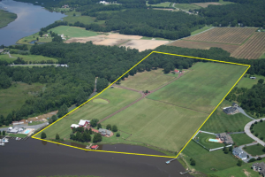
Surveying land has many uses. Boundary surveying, for instance, allows you to know where your property corners or property lines are. This is especially helpful when disputes with a neighbour or with other people arise in terms of where your property ends.

If your family wants to divide a tract of land and transfer ownership to other family members, a boundary survey is the first step to do so. If you’re having a building constructed, it is very important that you have the land surveyed to make sure that you are not encroaching onto other peoples’ property. A mistaken building location is very expensive to fix so you might as well invest in a boundary survey to prevent this.

A topographic survey, or topo survey for short, is another important type of land surveying. A topo survey is done to locate natural and man-made features on a particular parcel of land. A topographic survey is different in that the elevation of the land is surveyed which means it can show man-made underground features, retaining walls, utility lines and etc.

Before you start any kind of construction activity, it’s important to have a topo survey done in the area so they’ll have an accurate record of the land’s existing conditions. Yes, that spot with the new mall in the neighbourhood had to have a topo survey done first.

Now, a flood survey or flood determination – this is very important too. It isn’t evident just looking at a property whether you are at risk of flooding or not. And, in some cases, even looking at the flood maps doesn’t give you an accurate answer. The flood survey determines the elevation of the home and compares that to the base flood elevation.

This is the only way to be sure you’re not in a flood hazard zone. If you’ve just been told that you live in a flood-prone area, having that confirmed by a professional land surveyor would let you know how to best proceed.
When getting flood insurance, insurance companies would require an elevation certificate from you. A land surveyor would be able to assist you with this.

If a company wants to invest in another state, or if there is a national lender on a commercial project, they will likely need an ALTA Land Title Survey done before anything is constructed. An ALTA Land Title Survey is a lot like a regular boundary survey except that nationally accepted ALTA Standards are used to guide the surveying effort.

Land surveying standards vary widely from state to state and an ALTA Land Title Survey is used to cut down on this variation. Also, an ALTA Land Title Survey typically is more involved than the state standards variety. Because of this, an ALTA survey can be more anywhere from 50% to 200% more expensive than using the state standards only. If you need this type of survey, I suggest seeking an experienced land surveying company who is familiar with these additional requirements.
In summary, there are many uses for a land survey and for seeking the services of a land surveyor. If you’re unsure of your situation, consult Dallas Land Surveying at (214) 396-0266 today or go to the Contact page and send us an email.

Posted in construction, flood damage, land surveying, land surveyor | Tagged importance land surveying, Land Surveying, land surveying dallas, land surveying dallas tx, land surveying importance

How to Find Someone to Survey Your Property Boundary Correctly

Dallas Land Surveying Posted on May 19, 2018 by DallasLSMay 20, 2019

There are different reasons why somebody would need boundary surveying in their property. Often, this type of surveying is done if the owner of the property wants to legally place an item on the property such as a structure or a fence.

A Licensed Land Surveyor

When hiring a land surveyor, you have to make sure that he is duly licensed by your state. A “licensed” land surveyor means he was able to complete his studies, passed all exams and is certified to perform specific types of land surveys.

Hiring a licensed land surveyor is especially important if there is a dispute over a certain area of a property as the court would be asking for the current boundary survey result as well as testimony from a licensed land surveyor. With this being said, you also have to make sure that the surveyor you’re going to hire can also stand as an expert witness in court.

Looking for a Licensed Land Surveyor

boundary survey - property surveyIf your property has been surveyed before, it would be easier for you to contact that land surveyor again. This is the best option for several reasons; he already has all information about your property, making it easier for him to perform a new type of survey.
You can typically find your land surveyor’s information on the survey result given to you (if you’ve bought the property from somebody, for instance) or the result given to you by the surveyor himself.

If incase you don’t have the result on you, you can also check the markers put in place by the surveyor during the last survey done on your property. These markers, which looks like pegs, has he surveyor’s license number/ name on it. You can use these information to find the surveyor online.

If you can’t find the surveyor who worked on your property before, or if the property has never been surveyed, you should easily find a land surveyor in your area (for a land surveyor in the Dallas area, Davison County and surrounding areas, click here).

Important Points to Remember when Hiring a Boundary Surveyor

  • As mentioned, make sure that he or she is a licensed land surveyor.
  • He or she should have experience in performing boundary survey. If you’re going to pay somebody, you’d rather have someone who had done it before, right?
  • Look for someone easy to talk to. Communication is very important when hiring a land surveyor. You see, surveying is more of an art than a science – this is why land surveying results vary. It’s important that your surveyor understand why you’re having the survey, what you’re going to use the results for and how soon you’ll be needing the results.

For boundary surveying services in the Dallas, TX and Davidson County area of Texas, call us at (615) 645-1404 or fill out our contact form here.

Posted in boundary surveying | Tagged boundary survey, boundary survey dallas, boundary surveying, boundary surveying dallas, dallas boundary survey, dallas boundary surveying

Difference in FEMA Elevation Certificate and LOMA

Dallas Land Surveying Posted on March 6, 2018 by DallasLSMay 20, 2019

I get calls all the time from someone requesting an Elevation Certificate or Elevation Survey. Usually it’s because they’ve gotten a letter in the mail from their mortgage company telling them they have to get flood insurance. This leads them to contact their insurance company and that leads to a surveyor.

“purchasing flood insurance is mandatory…if the loan is federally insured or the lender is regulated by the federal government”

Purpose of the Elevation Certificate

FEMA Elevation CertificateAn Elevation Certificate is a form “…used to provide elevation information necessary to ensure compliance with community floodplain management ordinances, to determine the proper insurance premium rate, and to support a request for a Letter of Map Amendment (LOMA)…” Make sure that your surveyor uses the latest version of this form as it’s currently being revised (March 2016).

Surveyor Measures the Elevations

The surveyor determines the lowest floor elevation of the house, the lowest adjacent grade (LAG) elevations of the house, the elevation of the lowest element attached to the house (like a porch step,) and the lowest elevation of machinery or equipment servicing the building. The surveyor also identifies the building type according to the instructions in the Elevation Certificate form.

Base Flood Elevation Determined

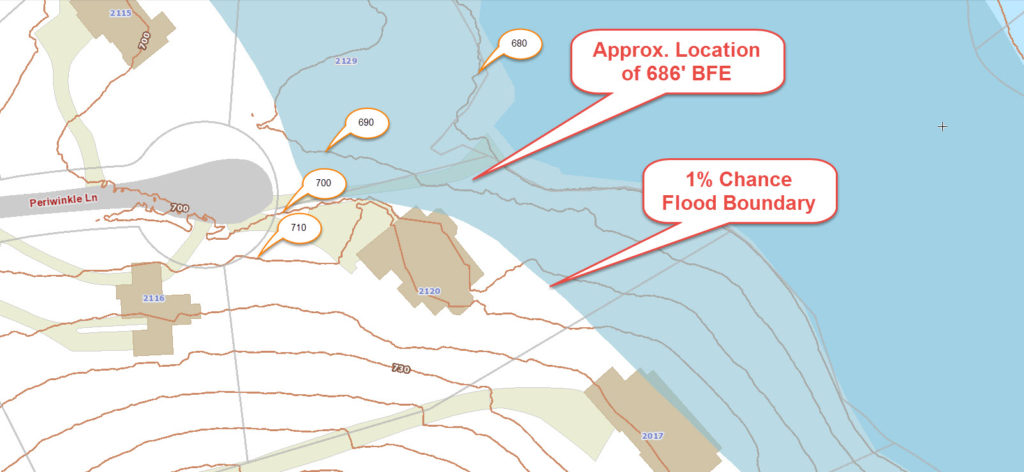
After these are measured, then the Base Flood Elevation (BFE) is determined from either the Flood Maps (FIRM), the Flood Insurance Study (FIS), or by the local community. The difference in elevation between this BFE and the LAG and/or Lowest Floor will determine the insurance premium rate.

LOMA Removes Flood Insurance Requirement

Even if an Elevation Certificate shows that your house is above the Base Flood Elevation at all points, you still have the requirement to obtain flood insurance. Only after the submission and approval of a Letter of Map Amendment (LOMA) can the Flood Map be amended and the Federal mandate for the purchase of flood insurance be removed.GIS with Flood Hazard Zone Overlay

The LOMA process can be done online and typically takes 30 days or less but sometimes a review of the LOMA submission can identify additional information that is needed.

It should be noted that the Elevation Certificate must be completed by a Land Surveyor, Engineer, or an Architect who is authorized by law to certify elevation information, though I don’t know of any Architects that will do these, and not too many Engineers.

Call Dallas Land Surveying at 214-396-0266 for help with an elevation certificate or LOMA.

Posted in elevation certificate, flood survey | Tagged elevation certificate, flood survey, flood zone

Post navigation

← Older posts
Newer posts →
Get Quote Button
© Copyright Boxer Survey USA
Dallas Land Surveying

Dallas, Texas
Phone: (214) 396-0266

Web Development and SEO by:
AuburnBusiness.com, LLC


Privacy Policy | Terms of Use

The owner of this website, Boxer Survey USA, provides coordination of professional land surveying and engineering services in all 50 states. The professional surveying and engineering services provided to you will be conducted by fully licensed professionals in your state.

↑