↓
 

Dallas Land Surveying

Local Land Surveyors in Dallas, TX

  • Home
  • Services in Texas
  • ALTA Survey
  • Boundary Surveying
  • Construction Survey
  • Drone LiDAR Mapping
  • Elevation Certificate
  • Land Surveying
  • Lot Survey – Closing Survey
  • Topographic Survey
  • Blog
  • Contact Us
Home 1 2 3 … 15 16 >>

Post navigation

← Older posts

Welcome to Dallas Land Surveying

Dallas Land Surveying Posted on December 18, 2018 by DallasLSMay 20, 2019

This site is intended to provide you with information on Land Surveying in the Dallas, TX and Dallas County and surrounding areas of Texas. If you’re looking for a Dallas Land Surveyor, you’ve come to the right place. If you’d rather talk to someone about your land surveying needs, please call our local number at (214) 396-0266 today. For more information, please continue to read.

land surveyingLand Surveyors are professionals who make precise measurements to determine the size and boundaries of a piece of real estate.  While this is a simplistic definition, boundary surveying is one of the most common types of surveying related to home and land owners. If you fall into the following categories, please click on the appropriate link for more information on that subject:

Dallas Land Surveying services:

    1. I need to know where my property corners or property lines are. (Boundary Survey)
    2. I have a loan closing or re-finance coming up on my home in a subdivision. (Lot Survey)
    3. I need a map of my property with contour lines to show elevation differences for my architect or engineer. (Topo Survey)
    4. I’ve just been told I’m in a flood zone or I’ve been told I need an elevation certificate in order to obtain flood insurance or prove I don’t need it. (Flood Survey)
    5. I’m purchasing a lot/house in a recorded subdivision. (Lot Survey – See Boundary Survey if you’re not in a subdivision.)
    6. I’m purchasing a larger tract of land, acreage, that hasn’t been subdivided in the past. (Boundary Survey)

Contact Dallas Land Surveying services TODAY at (214) 396-0266.

Posted in boundary surveying, elevation certificate, land surveying, land surveyor | Tagged boundary survey, Dallas Land Surveying, land surveyor, land surveyor dallas tx

Topographic Survey for Accessible Outdoor Routes at a Community Facility

Dallas Land Surveying Posted on October 12, 2026 by DallasLSOctober 8, 2026
Topographic survey for an accessible outdoor route at a community facility in Dallas, Texas

Half an inch of extra slope doesn’t look like much from the parking lot. For someone using a wheelchair, walker, or stroller, it can turn a short walk to the front door into a real struggle. Community facilities like libraries, recreation centers, churches, and clinics serve people of every ability, so their outdoor routes need to work for everyone.

A topographic survey gives designers the accurate ground data they need to plan those routes well. It shows where the land rises and falls, where water flows, and where existing features may get in the way. If your facility is planning new walkways or fixing old ones, start with the survey so design decisions rest on real measurements instead of guesses.

How a Topographic Survey Supports Accessible Outdoor Route Planning

An accessible route is a continuous path that people with disabilities can use to move between parking, sidewalks, entrances, and other spaces on a site. Federal and state accessibility standards set limits on how steep these routes can be. Designers can’t meet those limits without knowing the existing grades, which is exactly what the survey provides.

The survey also helps facility owners compare options. A route that looks shortest on a site plan may run up a steep bank. A longer path might stay gentle and avoid the need for ramps or handrails.

Measuring Existing Slopes and Elevation Changes Along Proposed Routes

The survey measures two kinds of slope along a route. Running slope is the slope in the direction you travel. Cross slope is the side-to-side slope across the walkway.

Both matter for accessibility. Under the 2010 ADA Standards, a walking surface with a running slope steeper than 1:20 is generally treated as a ramp, and cross slopes are generally limited to 1:48. Ramps then bring their own limits on slope, length, landings, and handrails. The exact standards that apply can vary by facility type, funding source, and jurisdiction, so your designer should confirm them for your project.

To capture these details, the surveyor collects spot elevations at close spacing along existing walks and planned routes. Small changes matter here, so the survey needs enough density to show low spots, humps, and lips at joints. Tell the surveyor up front that the data will support accessible design so they can plan the right level of detail.

Identifying Terrain Constraints Near Entrances and Pedestrian Connections

Entrances are where accessible routes most often run into trouble. Building floors usually sit above the surrounding ground so water drains away. That height difference has to be handled somewhere between the sidewalk and the door.

A topographic survey shows the finished floor elevation at each entrance and the grades around it. It also captures features that limit design choices, such as:

  • Existing steps, retaining walls, and planters
  • Utility boxes, light poles, and fire hydrants
  • Trees with roots near the surface
  • Curb ramps, crosswalks, and street sidewalk connections

The connection to the public sidewalk deserves close attention. Grades at the property line are often fixed by the street, so the route must work within them. Knowing those elevations early helps designers avoid surprises during construction or plan review.

Using Survey Data to Plan Walkway Grades and Drainage

Accessible walkways need to stay fairly flat, but they still have to shed water. Standing water and ice can make a level path unsafe or unusable. Good grading balances both needs.

The survey shows how water moves across the site today. It locates inlets, swales, gutters, and low areas where water collects after storms. With that information, a civil engineer can design walkways that drain to the side without exceeding cross slope limits.

Drainage problems often show up first at entrances and at the bottom of slopes. Water that runs toward a building or pools at a curb ramp creates both an access issue and a maintenance headache. Planning grades with accurate survey data reduces those risks before concrete is poured.

Existing Conditions Versus Proposed Grades

The survey records existing conditions only. The designer uses that data to create proposed grades for new walks and ramps. Comparing the two shows how much cut or fill is needed and helps estimate construction costs before the project goes to bid.

Coordinating Topographic Survey Findings With Accessible Route Design

A survey delivers the most value when the surveyor, designer, and facility owner share goals early. Before field work starts, agree on the survey limits, the level of detail, and the features to capture. A walkway project may need tighter elevation spacing than a general site map.

Make sure the survey includes a clear benchmark. A benchmark is a fixed point with a known elevation that ties all the measurements together. Contractors can then use the same benchmark for construction survey layout, helping position new walkways and ramps according to the approved design. 

Plan for follow-up as well. Many owners ask the surveyor to stake the new routes before construction and check grades after the work is done. Post-construction checks help confirm that slopes meet the design before the project is closed out. Permit and inspection steps can vary by municipality and project scope, so confirm them early if your schedule depends on approval.

Frequently Asked Questions

Why do I need a topographic survey for an accessible route project?

Accessibility standards limit how steep walks and ramps can be, and those limits depend on precise grades. A topographic survey measures existing slopes and elevations so designers can plan routes that fit. Without it, designs rely on rough estimates that may fail during construction. Fixing a walkway after it’s built usually costs far more than surveying first.

How detailed does the survey need to be?

The survey should be detailed enough to show small changes in slope along walks, ramps, and entrances. That usually means close spacing of spot elevations in the areas where routes will run. The right level of detail depends on the project scope and the designer’s needs. Discuss the purpose with your surveyor before field work begins.

Can an older site survey be used for this work?

An older survey may help with early planning, but it might not reflect current conditions. Sidewalks settle, trees grow, and past repairs change grades over time. It may also lack the detail needed for accessible design. Ask your designer whether a new or updated survey is needed for the project.

Who should order the topographic survey?

The facility owner usually orders the survey, often at the request of the architect or civil engineer. In public projects, the owning agency may handle the order directly. The designer can help write the survey scope so it captures what they need. Clear scope from the start helps avoid a second trip to the field.

Does the surveyor decide whether a route meets accessibility standards?

The surveyor measures existing and built conditions but doesn’t certify compliance with accessibility standards. Designers, building officials, and accessibility reviewers handle those decisions. The survey supplies the accurate measurements they rely on. Post-construction survey checks can show whether finished slopes match the design.

Posted in Topographic Survey | Tagged Topographic Survey

Aerial Survey for Planning Solar Canopies Over Large Parking Areas

Dallas Land Surveying Posted on October 5, 2026 by DallasLSOctober 1, 2026
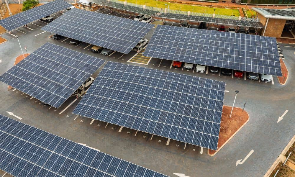
Aerial view of a large parking lot with solar panel canopies, parking spaces, and drive aisles, illustrating the site layout examined in an aerial survey

A large parking lot looks like open space from the road. Once you start placing solar canopy columns, it becomes a tight grid of drive aisles, light poles, islands, inlets and buried lines. An aerial survey gives a property owner a measured picture of that lot before anyone commits to a canopy layout.

Commercial campuses and retail centers around Dallas often have parking fields that cover more ground than the buildings they serve. That makes them a natural spot for solar canopies. The canopy still has to fit around a lot that already works every day for tenants, shoppers, delivery drivers and emergency crews.

Start With the Parking Area as a Design Constraint

The existing parking lot sets the rules for a solar canopy. Every column takes up space that a car, a curb or a drive lane uses today. Designers usually try to place columns along stall lines or at the heads of spaces so the site keeps close to its current parking count.

Drive aisles need enough width for cars to turn and back out. Fire lanes and truck routes may need extra height under the canopy. Local fire and building officials set those limits, so the exact numbers depend on the property and the city’s review.

An aerial survey helps because it shows the whole lot at once. The flight produces an orthomosaic, which is a single scaled image built from many overlapping aerial photos. With that image, the team can study stall patterns, aisle widths and traffic flow on one sheet and quickly see which rows can take a canopy.

Map the Features That Shape Canopy Placement

An aerial survey can capture most of the surface features that decide where canopy columns can go. For a typical commercial lot, that list includes:

  • Curbs, landscape islands and pavement edges
  • Light poles, signs and other fixed objects
  • Stall striping, accessible parking spaces and crosswalks
  • Storm drain inlets and visible utility covers
  • Trees and the spread of their branches
  • Nearby buildings, walls and overhead power lines

Each feature matters for its own reason. A light pole might need to move or come out if the canopy brings its own lighting. Trees can shade panels and drop leaves on them, and their roots may sit right where a foundation needs to go.

Aerial data only shows what sits on the surface. It can’t see water, gas, electric or fiber lines under the pavement. Canopy columns often rest on deep foundations, so the team should plan a utility locate before any drilling. The public 811 system marks lines owned by utility companies, and large commercial sites may also need a private locator for lines the owner controls. The aerial map gives those crews a clean base for recording what they find.

Connect Aerial Mapping With Survey Control and Site Data

Aerial imagery needs survey control before it can serve as reliable measurements. Survey control refers to points on the ground that a surveyor measures with GPS or other survey equipment and ties to a known coordinate system. Crews often set painted marks or targets on the pavement before the flight so the mapping team can fit the imagery to real positions and elevations.

Without that tie, an aerial map can look sharp and still sit out of position. A small shift might not matter for a first concept sketch. It starts to matter once an engineer places foundations and sets canopy heights.

Good control also lets the aerial data work with other records. The surveyor can bring together an existing boundary or ALTA survey, utility maps, as-built plans for the lot and the designer’s own base files. When everything shares one coordinate system, the team can lay the canopy design over real site conditions instead of rough estimates.

Check Existing Conditions Before Finalizing the Canopy Layout

A canopy changes how rain reaches the pavement. Water no longer falls evenly across the lot. It drops off the panel edges or runs to downspouts at the columns, and if it lands in a low spot or on a walkway, it can pond or leave a slick path to the door.

Aerial mapping can produce a surface model that shows the general shape of the ground. Parking lots often have very gentle slopes, though, and small grade changes decide where water goes. When the design depends on drainage, a surveyor may need to collect ground elevations along gutters, inlets and flow lines to fill in that detail.

This is also a good time to walk the lot with the aerial map in hand. Patched trenches, cracked pavement and sunken areas can point to old utility work or soft ground. If the owner already plans to repave or restripe, finishing that work before the columns go in usually takes less effort than working around them later.

Build the Survey Scope Around the Solar Project

The right survey scope depends on where the solar project stands and what the designer needs next. At the concept stage, aerial imagery with basic control may be enough to test canopy rows and rough panel counts. During final design, the team often needs tighter control, ground elevations at column locations, mapped utilities and boundary information near property lines or easements.

Ask the solar designer and structural engineer for a written list of their data needs. That list might name the coordinate system, file formats, contour spacing, utility detail and the areas that need ground checks. When the survey team gets this list before the flight, it can plan one trip instead of two.

For a retail center or corporate campus with several parking fields, phasing can shape the scope too. The team might fly the whole property once and add ground survey detail only where the first canopies will go. Later phases can then build on the same control and imagery. Once the design is final, construction staking can mark column locations in the field so crews build what the plans show.

Frequently Asked Questions

Can an aerial survey show individual parking spaces?

Often it can, especially when the striping is fresh and the imagery is clear. Faded paint, building shadows and parked cars can hide some lines. For planning, imagery usually works well for counting and outlining stalls, and a surveyor can confirm exact dimensions on the ground if the design calls for them.

Can an aerial survey be performed while a parking lot remains in use?

Many active lots can be flown, but parked cars block the pavement beneath them. Teams often schedule flights for early mornings, weekends or closed hours when the lot sits emptier. Sites near an airport may also need FAA airspace approval before a drone flight, which can affect timing.

Does a solar canopy project require property boundary information?

That depends on where the canopy sits and what the reviewing parties ask for. A canopy well inside the property may not need new boundary work. When columns or roof edges approach a property line, an easement or a neighboring parcel, the owner should find out exactly where those lines fall and check early with the city, lender or landlord.

Posted in lidar mapping | Tagged drone, lidar mapping

Drone Land Surveying for Stockpile Measurements on Active Material Yards

Dallas Land Surveying Posted on September 28, 2026 by DallasLSSeptember 24, 2026
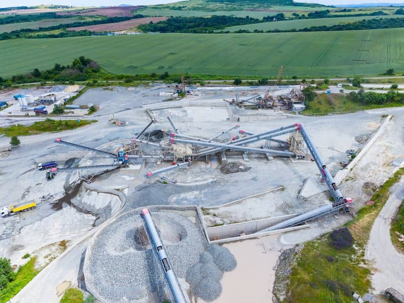
Drone land surveying view of stockpiles at an active material yard in Dallas, Texas.

A pile of crushed stone can look the same from the scale house for weeks. Meanwhile, trucks haul thousands of tons in and out, and the numbers on paper slowly drift away from what’s really in the yard. Drone land surveying closes that gap by measuring every pile from above in one short flight.

For yard managers, contractors, and anyone who reports inventory, the payoff is simple. You get volumes based on measured surfaces instead of eyeball guesses. This guide covers how the process works, how to plan flights around a busy yard, and what to ask for so the final report is something your team can use.

How Drone Land Surveying Measures Stockpile Volumes

Drone land surveying measures stockpiles by capturing hundreds of overlapping images or laser scans and building a 3D surface of each pile. Software compares that surface to a base surface underneath, and the space between the two is the volume. Results are usually reported in cubic yards and can be converted to tons.

The base surface matters more than most people expect. On a flat concrete pad, it’s easy to define. On a dirt yard that’s been scraped and filled for years, the surveyor may need an earlier ground survey or a careful estimate from the ground around the pile’s edge. Ask how the base will be set before the first flight, since it can shift the numbers more than the drone itself.

There are two main capture methods. Photogrammetry uses camera images and works well for most aggregate, sand, and soil piles. LiDAR uses laser pulses and handles dark material and steep faces better, though it usually costs more.

Planning Drone Flights Around Active Yard Operations

The best stockpile flights happen when equipment is parked away from the piles and the light is steady. Early mornings, lunch breaks, or weekend slots often work well. A pile that’s being loaded during the flight will show a half-moved face that doesn’t match any count.

Safety comes first on an active site. The pilot should hold an FAA Part 107 certificate, and sites near airports may need extra airspace approval. Wind, low sun, and haul road dust can all hurt image quality, so leave some room in the schedule for a weather delay.

A short prep call saves a return trip. Most surveyors will ask for the same basic details. Have these ready before the flight date:

  • Which piles need separate volumes and what material each one holds
  • When loading and hauling usually pause
  • Where power lines, conveyors, or tall structures sit
  • Who on site can hold equipment if needed

Establishing Reliable Ground Control for Stockpile Surveys

Ground control points are marked targets that the surveyor measures with high-precision GNSS equipment. . The drone data gets tied to these points so the 3D model sits at the right position and elevation. Without good control, a model can tilt or float slightly, and that small error spreads across every square foot of a large pile.

On a working yard, control points should sit outside truck and loader paths. Marks on a concrete slab, nails in a curb, or monuments set near fence lines tend to last. Temporary targets are fine for a one-time count, but they’ll get run over if left in a haul lane.

Many drones now record very precise positions for each photo using RTK or PPK systems. That can cut down how many control points are needed. A few independent check points still let the surveyor prove the model’s accuracy instead of assuming it.

Turning Survey Data Into Usable Volume Reports

A good volume report lists each pile by name or material and shows its measured volume. It should also include the survey date, the accuracy checks, a map of the pile outlines, and a note on how the base surface was set. If your team needs tons, the report should state which density factor was used.

Density is where many inventory numbers go sideways. The drone measures space. It can’t weigh anything, so your density values should come from your own scale tickets or lab tests instead of a generic table.

Ask for files in formats your team already uses. Most managers want a PDF summary, a spreadsheet of volumes, and a marked-up aerial image. Estimators may also want the surface files for their own software.

Using Repeat Surveys to Track Material Inventory Changes

Repeat surveys show how much material came in or went out between two dates. Many yards fly monthly or quarterly to match their reporting cycle. Year-end counts for audits are another common reason, so check timing with your accountant.

Consistency is what makes repeat surveys worth the cost. Use the same control points, base surfaces, and pile boundaries each time. If a pile gets moved or split, the report should note it so the month-to-month numbers still line up.

Over time, the data helps with more than counting. You can compare surveyed volumes against sales records to spot loss or density problems. You’ll also see which piles are creeping toward roads or drainage paths before they cause trouble.

Frequently Asked Questions

How accurate is drone stockpile measurement?

Accuracy depends on ground control, the capture method, and how well the base surface is defined. With good control and a clear base, results often land within a few percent of the true volume. Large piles usually measure more reliably than small, irregular ones. Ask your surveyor what accuracy to expect for your yard and how they’ll check it.

How long does a drone stockpile survey take?

Most yards can be flown in under an hour, though large sites take longer. Setting ground control may add time on the first visit. Processing and reporting often take a few business days. Turnaround can vary by yard size and workload, so confirm the schedule early if you have a reporting deadline.

Do we need to shut down the yard during the flight?

A full shutdown usually isn’t needed. Most surveyors only ask that equipment stay away from the piles being measured. Loaders can often keep working in other parts of the yard. Agree on the plan ahead of time so nobody on site is caught off guard.

Posted in lidar mapping | Tagged lidar mapping

Post navigation

← Older posts
Get Quote Button
© Copyright Boxer Survey USA
Dallas Land Surveying

Dallas, Texas
Phone: (214) 396-0266

Web Development and SEO by:
AuburnBusiness.com, LLC


Privacy Policy | Terms of Use

The owner of this website, Boxer Survey USA, provides coordination of professional land surveying and engineering services in all 50 states. The professional surveying and engineering services provided to you will be conducted by fully licensed professionals in your state.

↑