
↓
 

Dallas Land Surveying

Local Land Surveyors in Dallas, TX

  • Home
  • Services in Texas
  • ALTA Survey
  • Boundary Surveying
  • Construction Survey
  • Drone LiDAR Mapping
  • Elevation Certificate
  • Land Surveying
  • Topographic Survey
  • Blog
  • Contact Us
Home - Page 3 << 1 2 3 4 5 … 8 9 >>

Post navigation

← Older posts
Newer posts →

What Dallas Homeowners Should Consider Before Combining Outdoor Living Spaces Into One Backyard Project

Dallas Land Surveying Posted on June 19, 2026 by DallasLSJune 25, 2026
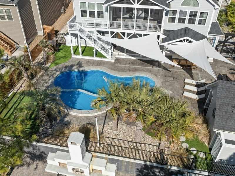
Integrated Dallas backyard featuring a pool, shade structures, landscaped areas, and connected outdoor living spaces.

Many Dallas homeowners start with one backyard idea and quickly end up with five on the list. A pool gets added, then a pergola, then an outdoor kitchen, and the whole backyard becomes part of the plan. Combining all those ideas into one project sounds great, but it takes careful thought to make everything work well together. Without a shared plan from the start, the finished yard often feels like a collection of separate additions rather than one connected space.

Creating One Outdoor Experience Instead of Several Separate Projects

Most backyard projects start small and grow fast. A homeowner wants a simple patio, the list expands, and suddenly a contractor is looking at a much bigger job than anyone planned for. The challenge at that point shifts from picking features to making sure they all fit together properly.

Thinking about the backyard as one complete space from the beginning changes how every decision gets made. The location of a pool affects where a patio can go. A pergola needs to work with shade patterns across the yard. An outdoor kitchen needs to sit close enough to the house for utility connections but far enough away to work as a real gathering spot. Planning these things together from day one avoids the conflicts that come up when features get added one at a time.

Balancing Privacy, Entertainment, and Everyday Use

A backyard serves many different purposes, and not all of them happen at the same time. Some areas need to handle large gatherings with open space and plenty of seating. Other parts of the yard work better as quiet spots for relaxing or letting kids play without being in the middle of everything.

Getting that balance right takes planning before any work begins. A family that entertains often needs easy flow between the kitchen, dining area, and pool. A household with young children needs clear sight lines from multiple spots around the yard. Privacy from neighboring properties matters more in some areas than others, and placing structures and fencing with all of that in mind produces a yard that works well every day, not just on special occasions.

Features That Often Need to Work Together

Some backyard features seem easy to plan on their own, but most of them directly affect what can go around them. The ones that most often need to be coordinated include:

  • Pools and patios, since deck surface, drainage, and equipment placement all affect each other
  • Outdoor kitchens and seating areas, which need good positioning for both function and airflow
  • Pergolas and shade structures, which change sun exposure across the surrounding space
  • Walkways and lighting systems, since path placement determines where lighting connects the space at night
  • Gardens and gathering areas, where planting choices affect privacy and how usable nearby space feels
  • Storage areas and detached structures, which need spots that don’t block access or cut into usable yard space

When these features get planned together, the yard works as one connected space. When they get added one at a time without a shared plan, conflicts show up during construction and the finished result feels pieced together.

Thinking Beyond the First Summer

A backyard that works well for a family right now might not work as well five years from now. Kids get older, hobbies change, and entertaining styles shift over time. A yard designed only for the present moment can start feeling limiting sooner than anyone expected.

Building some flexibility into the plan from the start addresses this without adding much cost upfront. Leaving room for a future shade structure in an area that gets heavy afternoon sun is a small decision that pays off later. Designing the patio large enough to fit a longer table when the family grows costs almost nothing extra at the planning stage but avoids an expensive expansion down the road. Most homeowners only think about this after wishing they had.

Building an Outdoor Space That Grows With the Property

The best backyard projects leave room for what comes next. A yard built out fully in one phase with no thought given to future additions tends to run into problems when a homeowner wants to expand later. A new structure ends up blocking drainage, or a future garden conflicts with irrigation that was already installed underground.

Accurate land surveying information supports long-range thinking from the start. Knowing exact property boundaries, utility locations, and grade changes across the yard gives homeowners and contractors what they need to place improvements correctly. A yard planned with that kind of solid foundation tends to hold its value better and adapt more easily as the household’s needs change over the years.

FAQ

Why do homeowners combine multiple backyard projects into one plan?
Combining projects from the start creates a more connected outdoor space and is usually more cost-effective than adding features one at a time without a shared plan.

Which backyard features are commonly designed together?
Pools, patios, outdoor kitchens, pergolas, walkways and seating areas are frequently planned together because their placement directly affects each other.

Why is long-term planning important for outdoor living spaces?
Family needs change over time, and a yard planned with built-in flexibility tends to work better for longer without requiring major changes or costly additions.

Can different backyard features affect one another?
Yes. The location and size of one feature regularly affects what can go nearby, which is why coordinating the full plan before work starts leads to better results.

How does land surveying help with large backyard projects?
It provides accurate information about property boundaries, grade changes and utility locations, helping homeowners and contractors make placement decisions that work well now and support future improvements.

Posted in land surveying | Tagged construction survey

How Dallas Redevelopment Projects Benefit From Updated Land Surveying Information

Dallas Land Surveying Posted on June 18, 2026 by DallasLSJune 25, 2026
Construction professional supervising a large development project and planning future site improvements.

Dallas has a lot of older properties getting a second life, and land surveying is one of the first steps that keeps those projects on track. Skipping it or using old data almost always leads to problems that cost more to fix than the survey would have. Most project teams that run into budget surprises during redevelopment trace it back to bad or outdated site information.

Old Properties Bring Old Surprises

Older Dallas properties have usually been through a lot before a new developer takes over. Past owners added buildings, moved parking areas, and changed utilities without always updating the original plans. The site on paper and the site on the ground often don’t match at all by the time redevelopment starts.

That gap causes real problems once work begins. A utility line moved 15 years ago won’t show up on old drawings, but a crew will find it fast when they start digging. Updated land surveying shows what’s actually on the property right now, not what was there when it was first built. That current picture is what keeps a project from hitting unexpected costs mid-construction.

Turning Yesterday’s Sites Into Tomorrow’s Projects

Not every redevelopment project starts with a wrecking ball. Many older Dallas warehouses, retail centers, and office buildings get turned into something completely new while the original structure stays standing. A former big-box store becomes a clinic, or an old warehouse becomes apartments, and the existing building stays in place the whole time.

For that kind of project, accurate survey data is a must. The developer needs to know exactly where the building sits on the lot, how close it is to the property line, and where utilities connect. Using a survey from 20 years ago on a project like this is a real gamble, and most lenders won’t accept that kind of risk on a serious investment.

Existing Features That Often Influence Redevelopment Plans

Older commercial sites come with a lot of existing features that affect how the new project gets designed. These are some of the most common ones that shape decisions early on:

  • Parking lots that need to be redesigned for a new use
  • Retaining walls that limit grading and drainage options
  • Drainage structures that may need to move
  • Utility connections that may not work for the new building
  • Access drives that affect where entries and exits can go
  • Loading areas that don’t fit the new plan

Knowing where all of these things sit before design work starts saves a lot of backtracking. Updated land surveying puts it all in one accurate document so the whole team works from the same current information.

Not Every Piece of the Property Ages the Same Way

A property that’s been around for 30 years doesn’t age evenly. One section might have been renovated twice while another part looks exactly the same as the day it was built. Additions and upgrades happen years apart, and they don’t always get properly recorded anywhere.

Old site plans miss all of that. A drawing from 2005 shows the original building but won’t show the drive-through lane added in 2012 or the transformer pad installed a few years ago. Updated land surveying covers the whole property as it actually exists today. That matters because planning from incomplete information leads to constant corrections during construction, and corrections cost money and time.

Building Flexibility Into the Next Chapter

Most redevelopment projects aren’t planned for just one use or one phase. A developer turning an old retail site into a mixed-use property is already thinking about future tenants, expansions, and how the site might need to change over the next several years. Planning for that flexibility now makes future decisions a lot cheaper and simpler.

Current survey data supports that kind of long-range planning. When a developer knows exactly where utilities, access points, and boundaries sit, they can design the site to leave room for what comes next. Building on outdated information creates conflicts later, when a future expansion hits something that wasn’t on any plan, and fixing that after the fact costs far more than doing the survey right the first time.

FAQs

What types of properties are commonly redeveloped in Dallas?
Older retail centers, warehouses, office buildings, industrial sites and residential properties all go through redevelopment regularly as the city grows and demand for different uses changes.

Why is updated land surveying important for redevelopment?
It shows the current condition of the property instead of relying on old records that may not reflect years of changes and additions made by previous owners.

Can old site plans differ from what is actually on the ground?
Yes. Additions, utility changes and other improvements made over the years often create big differences between old documents and what’s physically on the site today.

Does redevelopment always involve demolishing existing structures?
No. Many projects keep the existing building and adapt it for a completely new use, which makes current site data even more important for accurate planning.

Who benefits from updated land surveying information?
Developers, investors, architects, engineers and property owners all need current site data to make good decisions throughout the planning and construction process.

Posted in land surveying | Tagged land survey

Welcome to Dallas Land Surveying

Dallas Land Surveying Posted on December 18, 2018 by DallasLSMay 20, 2019

This site is intended to provide you with information on Land Surveying in the Dallas, TX and Dallas County and surrounding areas of Texas. If you’re looking for a Dallas Land Surveyor, you’ve come to the right place. If you’d rather talk to someone about your land surveying needs, please call our local number at (214) 396-0266 today. For more information, please continue to read.

land surveyingLand Surveyors are professionals who make precise measurements to determine the size and boundaries of a piece of real estate.  While this is a simplistic definition, boundary surveying is one of the most common types of surveying related to home and land owners. If you fall into the following categories, please click on the appropriate link for more information on that subject:

Dallas Land Surveying services:

    1. I need to know where my property corners or property lines are. (Boundary Survey)
    2. I have a loan closing or re-finance coming up on my home in a subdivision. (Lot Survey)
    3. I need a map of my property with contour lines to show elevation differences for my architect or engineer. (Topo Survey)
    4. I’ve just been told I’m in a flood zone or I’ve been told I need an elevation certificate in order to obtain flood insurance or prove I don’t need it. (Flood Survey)
    5. I’m purchasing a lot/house in a recorded subdivision. (Lot Survey – See Boundary Survey if you’re not in a subdivision.)
    6. I’m purchasing a larger tract of land, acreage, that hasn’t been subdivided in the past. (Boundary Survey)

Contact Dallas Land Surveying services TODAY at (214) 396-0266.

Posted in boundary surveying, elevation certificate, land surveying, land surveyor | Tagged boundary survey, Dallas Land Surveying, land surveyor, land surveyor dallas tx

Post navigation

← Older posts
Newer posts →
Get Quote Button
© Copyright Boxer Survey USA
Dallas Land Surveying

Dallas, Texas
Phone: (214) 396-0266

Web Development and SEO by:
AuburnBusiness.com, LLC


Privacy Policy | Terms of Use

The owner of this website, Boxer Survey USA, provides coordination of professional land surveying and engineering services in all 50 states. The professional surveying and engineering services provided to you will be conducted by fully licensed professionals in your state.

↑